Why Understanding Your Flood Risk Matters More Than Ever
Flood insurance risk assessment is the process of evaluating your property’s likelihood of flooding and potential damage costs to determine appropriate insurance coverage and premiums. This assessment considers factors like your flood zone, elevation, distance to water sources, and local flood history.
Quick Answer: What You Need to Know
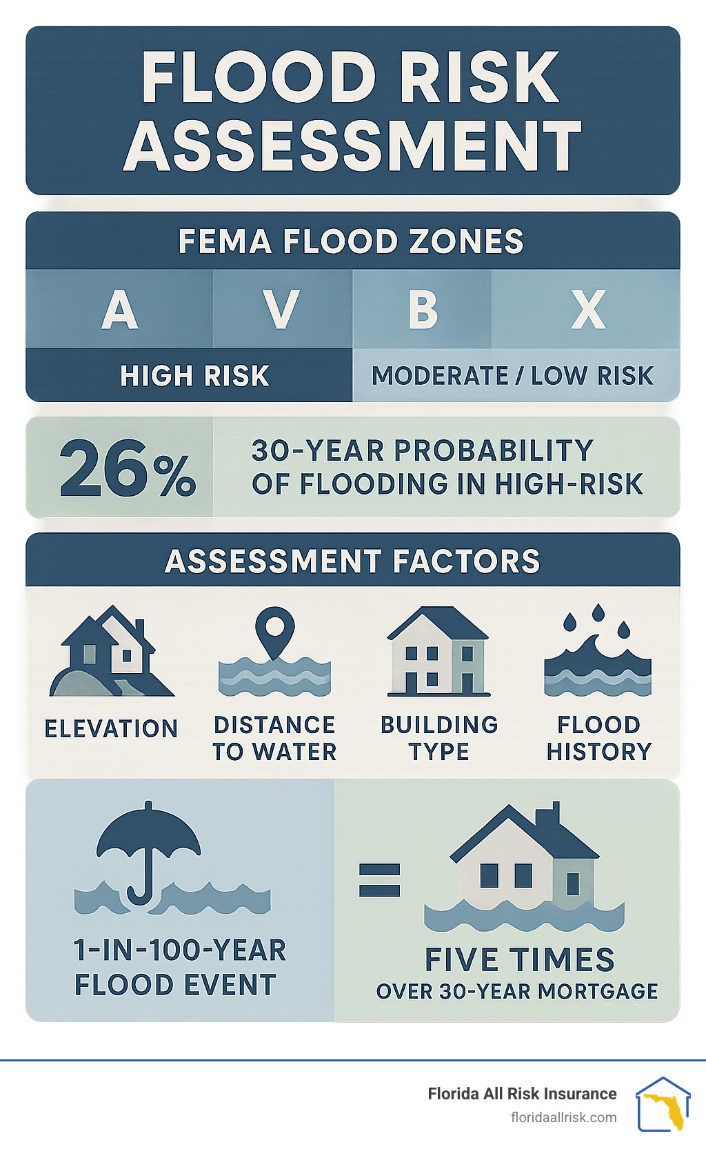
– High-risk zones (A, V): 1 in 4 chance of flooding over 30 years, insurance required
– Moderate/low-risk zones (B, C, X): Still account for 40% of all flood claims
– Assessment factors: Location, elevation, building type, flood history
– Cost impact: Proper assessment can reduce premiums through mitigation credits
The numbers tell a sobering story about flood risk in America. Over the past 20 years, 99% of counties in the U.S. have experienced a flood event. Even more surprising, over 40% of National Flood Insurance Program claims come from outside high-risk flood areas – those supposedly “safer” zones where many homeowners assume they’re protected.
Your chances of experiencing a flood over a 30-year mortgage are five times higher than having a house fire, yet most people focus on fire insurance while overlooking flood coverage. When floods do strike, the average NFIP claim payment from 2016-2021 was $68,000 – money that never has to be repaid, unlike disaster loans.
For Florida homeowners, understanding flood risk isn’t just about compliance – it’s about protecting your family’s financial future. Standard homeowners insurance doesn’t cover flood damage, making proper risk assessment crucial for adequate protection.
I’m Jason Miller, a second-generation insurance professional with over 20 years of experience helping Florida families steer complex insurance decisions. Throughout my career, I’ve guided thousands of clients through flood insurance risk assessment processes, helping them understand their true exposure and find affordable protection that fits their unique situations.
Glossary for Flood insurance risk assessment:
– fema flood zone map
– does flood zone ae require flood insurance in florida
– how much does flood insurance cost in florida
Flood Risk & FEMA Maps: Knowing Where You Stand
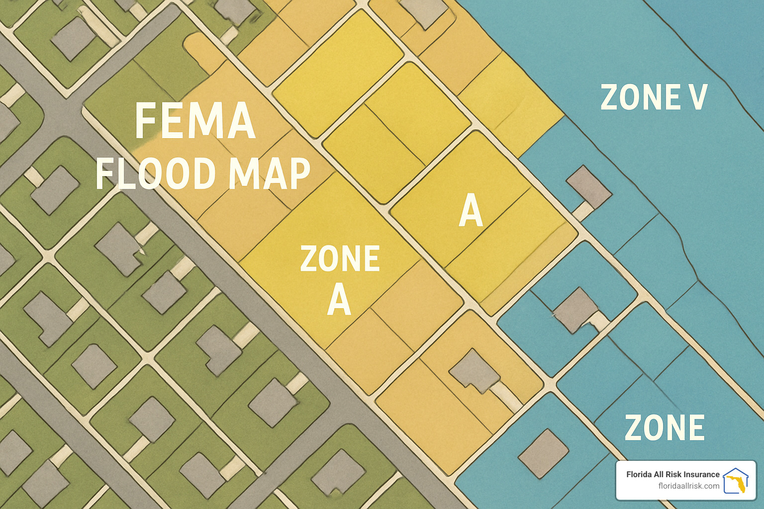
When I sit down with Florida homeowners to discuss their flood insurance risk assessment, the first thing we do is pull up their FEMA flood map. These maps determine whether your mortgage lender requires flood insurance and how much you’ll pay for coverage.
The maps divide flood risk into zones. Special Flood Hazard Areas (SFHAs) are the high-risk zones marked with letters A and V. These areas face at least a 1% annual chance of flooding – what experts call the “100-year flood.”
Here’s where it gets interesting: that “100-year flood” name is misleading. It doesn’t mean flooding happens once every century. Instead, you have a 1% chance each year, which adds up to a 26% chance over a 30-year mortgage. Would you buy a house if someone told you there’s a one-in-four chance it could flood during your mortgage term?
Zone A covers general floodplains where FEMA knows flooding can happen but hasn’t mapped detailed water depths. Zone V is for coastal areas where you get flooding plus dangerous waves.
If your home sits in an A or V zone and you have a federally backed mortgage, flood insurance isn’t optional. It’s required. But here’s what many people don’t realize: even in the “safer” zones marked B, C, or X, flooding still happens. In fact, 40% of all flood insurance claims come from these moderate- to low-risk areas.
Florida communities can earn discounts through the Community Rating System (CRS). When your city or county goes above and beyond minimum flood management requirements, residents get 5% to 45% discounts on flood insurance.
Interpreting Flood Zones and Elevations
Base Flood Elevation (BFE) is the magic number that can make or break your flood insurance costs. It’s the height floodwater is expected to reach during that 1% annual chance flood. If your home sits above the BFE, you’re in better shape both for actual flooding and for insurance rates.
This is where an elevation certificate becomes your best friend. A licensed surveyor measures exactly how high your property sits compared to the BFE. I’ve helped clients save hundreds of dollars annually when their elevation certificates showed their homes were higher than FEMA originally thought.
Limitations of Current FEMA Mapping
FEMA’s maps are impressive, but they’re not perfect. Many rely on outdated rainfall data that doesn’t reflect how storms have changed over the decades. The maps also miss pluvial flooding – the kind that happens when storm drains can’t keep up with heavy rain.
Climate change adds another wrinkle. Historical flood patterns don’t necessarily predict future flooding when weather systems are intensifying and sea levels are rising.
First Street Foundation found that actual flood risk is about 2.2 times higher than FEMA maps show. That’s a significant gap that affects millions of properties nationwide.
Accessing & Appealing Your Flood Map
Getting your flood map information is straightforward. Visit FEMA’s Map Service Center and type in your address. You’ll see your flood zone and can download a FIRMette.
If you think your flood zone is wrong, you’re not stuck with it. The Letter of Map Change (LOMC) process lets you challenge your designation. You’ll need technical data, usually from a licensed surveyor or engineer, proving your property has lower flood risk than mapped.
For more detailed information about how flood zones affect insurance requirements, check out our guide on FEMA flood zone maps.
Flood Insurance Risk Assessment—Tools & Techniques
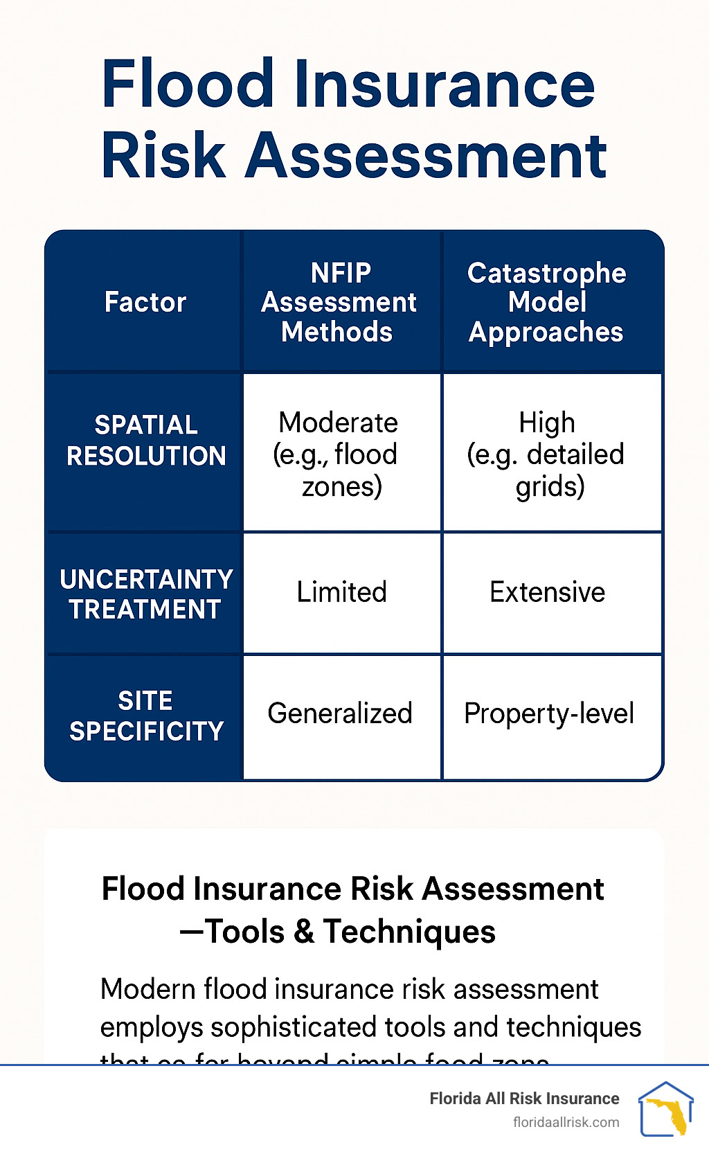
The world of flood insurance risk assessment has evolved dramatically over the past few years. NFIP Risk Rating 2.0 changed everything when it launched. Instead of treating all properties in Zone A the same way, this system looks at your specific property’s unique characteristics. It considers how far you are from water sources, your exact elevation, what it would cost to rebuild your home, and how often flooding actually happens in your area.
Professional engineers and insurance companies use sophisticated tools like the U.S. Army Corps of Engineers’ HEC-FDA software to dive deep into flood risk analysis. You can learn more about these assessment methods if you’re curious about the technical details.
Catastrophe models take a different approach entirely. These computer programs create thousands of imaginary flood scenarios to see how each one would affect your property. Private insurers love these models because they account for things like how fast the water moves and whether debris might slam into your house.
The science behind modern flood risk assessment rests on four key pillars: hazard (how likely and severe flooding might be), exposure (what you have at risk), vulnerability (how easily your property could be damaged), and performance (how well any flood protection measures work).
Flood Insurance Risk Assessment for Homeowners (DIY Toolkit)
You don’t need an engineering degree to get a solid understanding of your property’s flood risk. Several free tools can help you conduct your own basic flood insurance risk assessment.
FEMA’s Map Service Center should be your first stop. This is where you’ll find your official flood zone and can download detailed flood maps for your area.
Risk Factor has become one of my favorite tools to recommend to homeowners. Unlike FEMA maps that might be years old, Risk Factor provides current flood risk scores for your specific property and even projects what conditions might look like in the future.
ClimateCheck offers flood assessments alongside other climate hazards, though I’ve learned to take some private tools with a grain of salt. Always cross-reference with official sources.
For Florida homeowners, NOAA’s flood gauges provide invaluable historical context. You can see how nearby rivers and streams have behaved over time and access flood forecasts.
USGS National Map Viewer helps you determine your property’s exact elevation above sea level – crucial information for understanding flood risk, especially if you’re anywhere near the coast.
FloodFactor reports round out the toolkit with property-specific flood history and risk assessments.
Here’s how I recommend approaching your DIY assessment: Start with your FEMA flood zone, then determine your property’s elevation. Research any historical flooding in your area and take a good look at nearby water sources and drainage patterns. Don’t forget to consider future conditions like sea level rise, then review your current insurance coverage to see if it matches your actual risk.
Professional Flood Insurance Risk Assessment: When to Bring in Experts
Sometimes DIY tools aren’t enough, and you need to call in the professionals. I typically recommend professional flood insurance risk assessment when you’re planning construction projects in flood-prone areas, making substantial improvements to existing structures, or dealing with disputed flood zone designations.
Licensed surveyors are your go-to professionals for elevation certificates and detailed topographic surveys. Civil engineers become essential when you’re dealing with complex properties or need flood protection measures designed. Flood risk surveyors specialize specifically in flood hazard assessment and can provide comprehensive risk evaluations custom for insurance purposes.
Professional assessments typically run $300 to $1,000 for residential properties, with turnaround times ranging from a few days to several weeks depending on how complex your situation is. While that’s real money upfront, I’ve seen these assessments pay for themselves many times over through reduced insurance premiums and better-informed decisions about protecting your property.
Property-Specific Flood Risk Factors You Can’t Ignore
When conducting a flood insurance risk assessment, your property’s unique characteristics matter far more than many homeowners realize. I’ve seen two houses on the same street face completely different flood outcomes simply because of small differences in their specific features.
Distance to water sources is the obvious starting point, but it’s not always what you’d expect. Yes, being next to a river or lake increases your risk. But I’ve worked with clients whose homes flooded despite being miles from any obvious water source – all because of poor storm drainage or unusual land contours that channeled water their way.
Ground elevation can make or break your flood experience. Even a difference of just two or three feet can mean the difference between staying dry and dealing with thousands in flood damage. This is exactly why elevation certificates are so valuable – they often reveal that your property sits higher than FEMA’s broad-brush mapping suggests.
Your foundation type plays a huge role in how floods affect your home. Homes built on slabs are sitting ducks compared to liftd structures. If you have a crawl space or basement, you’re dealing with higher vulnerability. Meanwhile, those smart enough to have homes on pilings or liftd foundations typically watch floodwaters pass harmlessly beneath them.
The building materials in your home determine whether a flood is an inconvenience or a catastrophe. Ceramic tile and concrete can handle water exposure much better than hardwood floors and drywall. I always tell clients to think about what happens when these materials get soaked – some bounce back, others need complete replacement.
Utilities height is one of those factors that separates minor water damage from major insurance claims. When your air conditioning unit, water heater, or electrical panel sits at ground level, even a small flood can destroy expensive equipment. Smart homeowners lift these systems above expected flood levels.
Living near levees or dams creates a tricky risk situation. These structures do reduce how often floods happen, but if they fail or get overwhelmed, the damage can be catastrophic. It’s worth checking the National Levee Database to understand the condition of any flood control structures protecting your area.
Soil drainage affects how long water sticks around after a flood. Sandy soils let water drain away quickly, while clay soils hold onto water like a sponge. The longer water sits, the more damage it causes and the longer your recovery takes.
For coastal Florida properties, sea level rise is changing the flood game entirely. NOAA projects 10-12 inches of rise by 2050 – that might not sound like much, but it’s equivalent to all the rise we’ve seen over the past century. Areas that flood occasionally now will flood regularly in the coming decades.
Here’s something most people don’t know: lunar tide cycles are about to make coastal flooding much worse. NASA research shows that an 18.6-year lunar cycle will amplify high tides starting in the 2030s. Combined with rising seas, this means those “sunny day” floods will become much more common.
Precipitation trends are making historical flood data less reliable for predicting future risk. Climate change is intensifying rainfall events, so areas that rarely saw flooding in the past may face increased risk from more frequent heavy downpours. This is particularly relevant for inland Florida properties that depend on storm drainage systems designed for yesterday’s weather patterns.
Understanding these property-specific factors helps you make smarter decisions about insurance coverage and flood protection measures. Every property is unique, and a thorough flood insurance risk assessment considers all these variables to give you the complete picture of your flood risk.
Mitigation Measures & Insurance Cost Implications
Here’s where flood insurance risk assessment gets exciting – finding how smart mitigation measures can slash your flood risk and insurance costs simultaneously. I’ve watched countless Florida homeowners transform their flood vulnerability into manageable risk through strategic improvements.
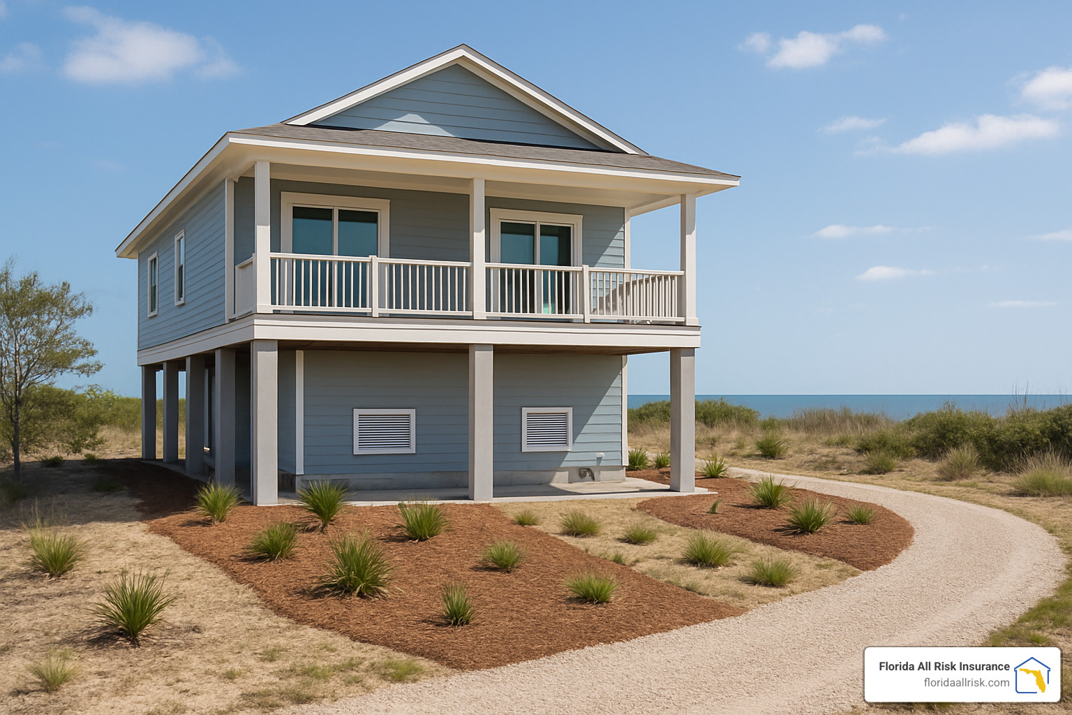
Elevation retrofits stand as the champion of flood mitigation. When you raise your home above base flood elevation, you’re essentially moving out of harm’s way. Yes, the upfront costs can be substantial – often $40,000 to $100,000 – but the insurance savings add up quickly. I’ve seen clients cut their annual premiums from $3,000 to $400 after elevation projects.
Flood vents offer a more affordable starting point. These engineered openings allow water to flow through enclosed areas like garages and crawl spaces, preventing the hydrostatic pressure that can literally push your foundation apart. Properly installed flood vents cost a few hundred dollars but can save thousands in structural damage.
The magic happens in your yard too. Land grading and drainage improvements direct water away from your foundation before it becomes a problem. French drains, rain gardens, and permeable paving turn your property into a water management system.
Your community’s participation in the Community Rating System (CRS) can reduce everyone’s flood insurance premiums by 5-45%. Communities earn CRS credits through activities like maintaining drainage systems, enforcing stricter building codes, and providing flood warning systems.
The game-changer is how NFIP Risk Rating 2.0 now recognizes mitigation efforts. The new system considers flood-resistant features, proper elevation, and protective measures when calculating your premium. Properties with comprehensive flood protection see real savings, even in high-risk areas.
Private insurance alternatives often provide even more flexibility in recognizing mitigation measures. Some private insurers offer significantly better rates for well-protected properties, creating more options for homeowners who’ve invested in flood protection.
For detailed information about how these mitigation measures affect your specific costs, check out our comprehensive guide on how much flood insurance costs in Florida.
Reducing Premiums After a Flood Insurance Risk Assessment
A thorough flood insurance risk assessment often uncovers hidden opportunities to reduce your premiums. The most powerful tool in your arsenal is the elevation certificate. This document, prepared by a licensed surveyor, can provide substantial savings if it shows your property sits higher than FEMA maps indicate.
I’ve helped clients save hundreds of dollars annually simply by documenting their properties’ actual elevation. One client in Tampa Bay saved $800 per year because her home was built two feet higher than the flood maps suggested. The $500 elevation certificate paid for itself in just eight months.
Higher deductibles offer another path to premium reduction, though this strategy requires careful consideration. Increasing your deductible from $1,000 to $5,000 might save you $200-400 annually, but you’ll pay more out-of-pocket if you file a claim.
Preparing for and Responding to Flood Events
Even with comprehensive flood insurance risk assessment and top-notch mitigation measures, flood preparation remains your final line of defense. The Ready.gov flood preparedness checklist provides detailed guidance for before, during, and after flood events.
Evacuation routes deserve special attention in Florida, where hurricanes can bring both storm surge and inland flooding. Plan multiple routes and practice them with your family.
Your emergency kit should include water (one gallon per person per day), non-perishable food, medications, flashlights, batteries, and copies of important documents stored in waterproof containers.
When flooding does occur, post-flood claims steps start with safety. Don’t enter flood-damaged buildings until authorities declare them safe. Document damage thoroughly with photos and video before cleanup begins. Contact your insurance company immediately – most insurers have 24-hour claims hotlines specifically for disasters.
Frequently Asked Questions about Flood Insurance Risk Assessment
What is a “1-in-100-year” flood really?
Here’s where flood terminology gets confusing, and I see this misunderstanding trip up homeowners all the time. The “1-in-100-year flood” has nothing to do with floods happening once every century.
What it actually means is there’s a 1% chance of this level of flooding occurring in any given year. Think of it like flipping a coin – just because you get heads doesn’t mean you can’t get heads again on the next flip.
Over the life of a 30-year mortgage, you actually have a 26% chance of experiencing a “100-year flood.” That’s roughly one in four – pretty significant odds when you’re talking about potential damage to your biggest investment.
This 1% annual exceedance probability (AEP) is what FEMA uses to define high-risk flood zones and determine where flood insurance is mandatory. But here’s the kicker: actual flood risk often exceeds these statistical models. Climate change, new development, and aging infrastructure can all increase your real flood risk beyond what the historical data suggests.
I’ve had clients experience multiple “100-year floods” within just a few years. It happens more often than you’d think, which is why proper flood insurance risk assessment looks beyond just the statistical labels.
Does Flood Zone X mean I’m safe?
This is probably the most dangerous assumption I encounter as an insurance professional. Flood Zone X creates a false sense of security that has cost Florida homeowners millions in uninsured flood damage.
Yes, Zone X areas have less than a 1% annual chance of the “big flood.” But they’re absolutely not flood-proof. The numbers tell the real story: 40% of all flood insurance claims come from outside the high-risk zones, including plenty from Zone X properties.
I’ve personally helped Zone X homeowners file claims after their homes flooded from overwhelmed storm drains during heavy summer rains, unusual storm surge during coastal storms, and even broken water mains that created localized flooding. None of these scenarios cared about their flood zone designation.
Zone X areas flood because of changing conditions that the maps don’t always capture. New development upstream can change drainage patterns. Aging infrastructure fails during heavy rains. Storm surge can reach farther inland than historical models predicted.
The good news? Flood insurance in Zone X areas typically costs much less than in high-risk zones. FEMA actually recommends coverage for all properties regardless of zone, and the lower premiums in Zone X make this protection quite affordable.
How will NFIP Risk Rating 2.0 change my premium?
Risk Rating 2.0 represents the biggest shake-up in flood insurance risk assessment that I’ve seen in my 20+ years in this business. It affects about 77% of all flood insurance policies, and most of those folks are seeing their premiums go up.
The old system was pretty simple – your flood zone determined your rate. Two identical houses in the same zone paid the same premium. The new system looks at each property individually, considering distance to water sources, property elevation, rebuilding costs, flood frequency, and even foundation type.
This means your neighbor might pay significantly more or less than you, even if you’re in the same flood zone. The system is trying to match premiums more closely to actual risk.
Here’s what I’m seeing with my clients: some properties are getting premium decreases because their individual risk factors are actually lower than their flood zone suggested. But more commonly, premiums are increasing as the new system captures risk factors that weren’t considered before.
The increases are being phased in over several years to avoid sticker shock, but the changes can still be substantial. The silver lining is that the pricing is now more accurate, which helps everyone make better decisions about their flood protection.
If you’re concerned about how Risk Rating 2.0 might affect your premiums, that’s exactly the kind of situation where working with an experienced agent makes all the difference. We can help you understand your new rate and explore options to manage costs.
Conclusion
Understanding flood insurance risk assessment is crucial for protecting your Florida property and financial future. The process involves much more than simply checking your FEMA flood zone – it requires evaluating multiple risk factors, understanding assessment methodologies, and considering mitigation opportunities that can save you money while keeping your family safe.
After two decades in the insurance industry, I’ve seen too many families caught off guard by floods they never expected. The good news? With proper assessment and planning, you can avoid becoming one of those statistics.
At Florida All Risk Insurance, we’ve helped thousands of Florida families steer complex flood insurance decisions. Our experience in St. Petersburg and throughout Florida gives us unique insights into local flood risks and insurance solutions.
Your property’s flood risk is unique. Two homes on the same street can have dramatically different risk profiles based on elevation, foundation type, and proximity to water sources. That’s why cookie-cutter insurance solutions often fall short when floods actually occur.
The flood insurance landscape continues evolving with Risk Rating 2.0, climate change impacts, and new assessment technologies. These changes create both challenges and opportunities for savvy homeowners.
Our independent agency status gives us access to multiple carriers, which means we can shop the market to find coverage that fits your needs and budget. Whether you need basic NFIP coverage or prefer improved private market options, we’ll help you make an informed decision.
Don’t let flood risk catch you unprepared. The average flood claim of $68,000 can devastate families who thought they were protected by their homeowners policy. Unlike disaster loans that must be repaid with interest, flood insurance provides money you never have to pay back.
Ready to take the next step in protecting your property? Visit our comprehensive flood coverage information to learn more about your options, or contact us directly to discuss your specific flood insurance needs.
Your financial security is too important to leave to chance. Let’s work together to ensure your family has the protection they deserve, at a price that makes sense for your budget.